
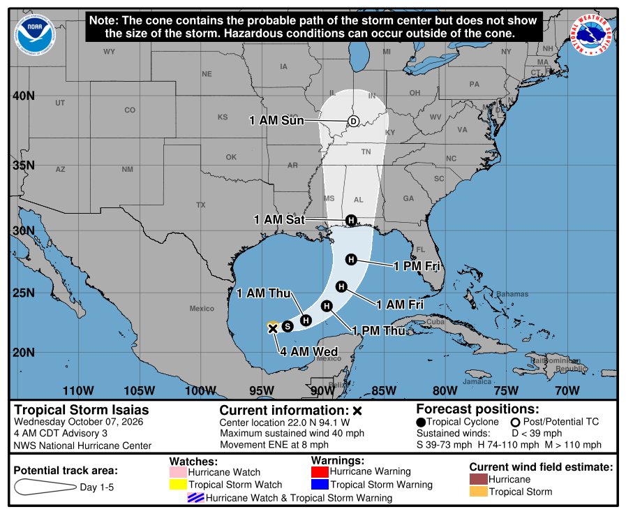
Tropical Storm Isaias formed in the southern Gulf overnight, and forecasters expect it to become a hurricane by Thursday and hit the northern Gulf Coast late Friday. The National Hurricane Center now forecasts it to peak at 110 mph, a strong Category 2, over the central Gulf.
If you live anywhere from southeast Louisiana to the Florida Panhandle, this is the week to get ready. If you don’t, you may still feel it at the gas pump.

Where is Hurricane Isaias expected to hit?
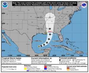
As of the NHC’s 4 a.m. CDT advisory, Isaias was about 580 miles southwest of the mouth of the Mississippi River with 40 mph winds, moving east-northeast at 8 mph. It’s expected to pass north of Mexico’s Yucatan Peninsula Thursday, then turn north toward the U.S. coast Friday.

The forecast track brings the center ashore late Friday night near the Alabama coast and the western Florida Panhandle, with 85 mph winds as it moves inland. But forecasters stressed that track confidence is “below-average,” and the latest forecast shifted east. Small changes matter a lot here. Watch for Hurricane and Storm Surge Watches, which the NHC said would “likely be required” for part of the northern Gulf Coast later Wednesday.
Why is Isaias expected to strengthen so fast?
The water. Sea surface temperatures along its path are 30 to 31 degrees Celsius, about 86 to 88 degrees Fahrenheit, and Fox Weather reports Gulf waters are at their warmest on record for this time of year in data going back to 1982. The NHC says rapid strengthening is likely over the next day or two before wind shear picks up near the coast.
Even if it weakens a bit before landfall, the NHC expects the storm’s wind field to spread out as it nears land, with rain and wind reaching far from the center, especially on the east side.
What should Gulf Coast residents expect?
- Rain: 3 to 6 inches from Friday through the weekend from far southeast Louisiana to the Florida Panhandle, with up to 10 inches in spots. Flash and urban flooding are possible.
- Inland rain: 1 to 3 inches, locally up to 5, across much of the Southeast as far north as the Tennessee Valley and the Carolinas.
- Wind and surge: An “increasing risk of dangerous wind and storm surge impacts,” according to the NHC.
- Surf: Life-threatening rip currents spreading toward the Gulf Coast late this week.
The NHC’s advice: if you’re between Louisiana and the Florida Panhandle, make sure your hurricane plan is in place now. That means knowing your evacuation zone, refilling prescriptions and filling the gas tank before lines form.
Will Isaias raise gas prices?
It could. According to Reuters, Isaias is headed across offshore fields that pump about 15% of U.S. crude oil, and six refineries run by Shell, Valero, Marathon, PBF and Chevron are in the region it could affect. As of Tuesday, operators had already shut in about 9% of Gulf oil production. Regular gas was averaging about $4.37 a gallon and diesel about $6.30, with prices already pushed up by the war with Iran.
The BeezLoop Take
Forecasters have been clear about two things: this storm will likely strengthen fast, and they aren’t sure exactly where it’ll land. That combination is the dangerous one. People tend to anchor on the single line in the middle of the cone, and Isaias could easily come ashore 50 miles from it.
The other lesson is about what record-warm water does. A storm that was a disorganized depression Monday is forecast to be a Category 2 by Friday. That’s less time to prepare than people are used to, and it’s arriving in October, when many people have mentally closed out hurricane season.
The open question is how much of Gulf energy production goes offline, and for how long. With gas already over $4, does a hurricane push it higher right before the midterms?
Also on BeezLoop: A September nor’easter flooded the coast from the Outer Banks to Cape Cod.
Sources: National Hurricane Center advisory · NHC forecast discussion · Reuters via Investing.com · Fox Weather · WWL-TV