
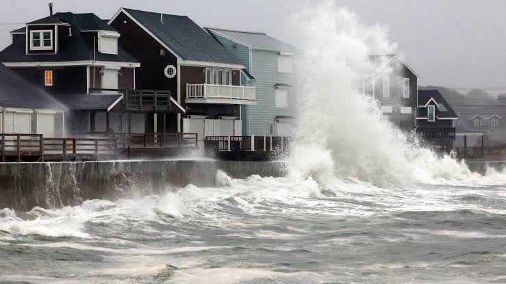
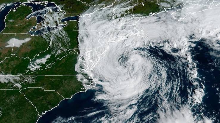
A strong early-season nor’easter is sitting on the East Coast and forecasters say it will linger into Monday. Tens of thousands of customers lost power Saturday, and the National Weather Service has major coastal flooding warnings out from the northern Outer Banks to Cape Cod.
Where it is worst right now
Coastal flooding peaks Saturday. The National Weather Service has issued major coastal flooding warnings for specific places, and this is the part worth checking against where you actually live:
- Atlantic City and coastal New Jersey
- Ocean City, both the Maryland and New Jersey ones
- Long Island
- The Norfolk metro area
- Downtown Boston
- Cape Cod, Martha’s Vineyard and Nantucket
The most significant flooding runs from North Carolina’s northern Outer Banks up to the Jersey Shore.

Wind: gusts over 50 mph from southern Cape Cod to Long Island, plus coastal and southern New Jersey, the Delaware coast and the Delmarva Peninsula. High wind warnings allow for gusts up to 60 mph through early Sunday morning around Boston, Providence, and the Delaware and New Jersey coasts. Occasional 40 to 50 mph gusts reach from the Outer Banks to coastal New England.
Power: trees down and outages in Massachusetts and Rhode Island, reaching as far south as Maryland and the Delmarva Peninsula, with tens of thousands out across Connecticut, New York and New Jersey. CNN put the Saturday total above 70,000 customers.
How many people this touches
Reporting puts the impact zone at more than 40 million people. NBC put the number under flood alerts at around 33 million. Forecasters expect the system to weaken but linger into Monday.
Those are different measurements and both are enormous. The practical version is the entire coastal corridor from Virginia to Maine.
What to actually do
Nothing exotic. The things that hurt people in a storm like this are boring and predictable. The grid is the part nobody thinks about until it fails, and demand on it is only going up.
- Do not drive through standing water. Most flood deaths in the US are people in vehicles. A foot of moving water can move a car.
- Coastal flooding runs on tide cycles, not on the clock. The worst is at high tide. Check your local tide times rather than assuming it is over because the rain stopped.
- Charge everything now if you are in the outage band, and treat any downed line as live.
- If you park near the water, move the car uphill before the tide, not during it.
- Check your county emergency page and weather.gov for your specific zone. Statewide forecasts hide big local differences.
Why a September nor’easter is unusual
Nor’easters are winter storms. The name describes the northeast winds that come off the counterclockwise rotation of a low pressure system tracking up the coast, and they normally show up between roughly October and March.
Getting one this strong in September means warm ocean water feeding a system that would usually need colder air to organize. It is early, and the coverage calling it rare is not hype.
The BeezLoop Take
The useful thing to say about a storm is not whether it is historic. It is which hour is dangerous and which road is closed, and that information is local. If you take one thing from this, make it the tide schedule. Coastal flooding is not continuous, it comes in cycles, and people get caught because the rain let up and they assumed the water would too.
The part worth arguing about is the infrastructure underneath. Tens of thousands of customers losing power to a September storm, before a single winter event, is not a freak outcome. It is what an aging overhead distribution grid does in 55 mph gusts, and it happens every year in the same places. Utilities and state regulators have known this for decades and burying lines keeps losing to the cost argument.
That cost argument deserves to be treated seriously rather than dismissed. Undergrounding is genuinely expensive, ratepayers pay for it, and the people pushing hardest for lower utility bills are often the same people who lose power. There is no free version. But the honest framing is a choice between paying now and paying in outages, spoiled food, missed shifts and generator fuel, and nobody puts that second number on a bill. Most households are already stretched thin, and an outage is an unbudgeted cost that lands on the people least able to absorb it.
The September timing is the part that should not get lost in the coverage of wind speeds. A storm this organized, this early, is running on ocean heat that was not there in the same quantity a few decades ago. You do not need to litigate anything broader to notice that the season for this kind of event is getting longer, and that coastal towns are budgeting for a winter problem that now arrives in early fall.
The question
If 70,000 people lose power to a September wind event, what happens in February? And how many more of these before undergrounding stops being too expensive?
Sources: CNN live updates · NBC News · CBS News · The Weather Channel · National Weather Service