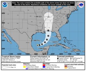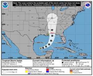

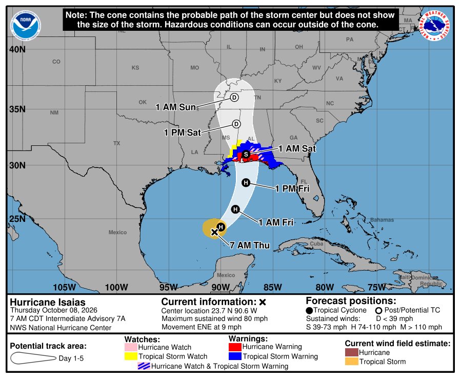
Isaias became the first hurricane of the Atlantic season overnight and is still strengthening. As of the National Hurricane Center’s 4 a.m. CDT advisory Thursday, it had 80 mph winds, and hurricane warnings now cover the coast from Ocean Springs, Mississippi, to the Bay/Gulf County line in Florida.
Hurricane conditions are expected Friday night into early Saturday. The NHC says preparations “should be rushed to completion today.”

Where is Hurricane Isaias going to hit?
The NHC forecast brings Isaias to about 110 mph, a strong Category 2, over the central Gulf overnight, then ashore near the Alabama-Florida line Friday evening or night at around 105 mph before it moves inland over Alabama. The storm was about 420 miles south-southwest of the mouth of the Mississippi River early Thursday, moving east-northeast at 9 mph.

- Hurricane Warning: Ocean Springs, Mississippi, to the Bay/Gulf County line, Florida. That includes Mobile, Gulf Shores, Pensacola, Destin, Fort Walton Beach and Panama City Beach.
- Storm Surge Warning: the mouth of the Mississippi River to the Steinhatchee River, Florida.
- Tropical Storm Warning: from the Jefferson/Plaquemines Parish line, Louisiana, to west of Ocean Springs, and east of the Bay/Gulf County line to the Aucilla River.
- Storm Surge Watch: the Steinhatchee River to Yankeetown, Florida.
How high could the storm surge get?
If the peak surge hits at high tide, the NHC says water could reach:
- 5 to 7 feet from Ocean Springs to Indian Pass, Florida, and in Mobile Bay.
- 4 to 6 feet from Indian Pass to the Steinhatchee River.
- 3 to 5 feet from the mouth of the Mississippi to Ocean Springs.
- 2 to 4 feet from the Steinhatchee River to Yankeetown.
Rain of 3 to 7 inches, with up to 10 in spots, is forecast from far southeast Louisiana to the Florida Panhandle from Friday through the weekend. The NHC warns residents in the hurricane warning to prepare for long-lasting power outages.
Who has to evacuate?
Okaloosa County ordered a mandatory evacuation for coastal Zones A and B starting at noon Thursday, WKRG reported. That covers Okaloosa Island and parts of coastal Fort Walton Beach, Destin, Mary Esther and Niceville. Visitors were asked to leave starting Wednesday night. Shelters are opening at Davidson Middle School in Crestview, which takes pets and people with special needs, and at Northwest Florida State College’s Raider Arena in Niceville, FOX10 reported. Evacuations were also ordered for a vulnerable Alabama barrier island. Check your county emergency management office, because orders are changing quickly.
Gov. Ron DeSantis declared a state of emergency for 25 Florida counties Tuesday night, and Alabama has declared one too. Here’s which Florida counties are covered.
The BeezLoop Take
Isaias went from a disorganized depression on Monday to a strengthening hurricane by Thursday. That’s what record-warm Gulf water does, and it leaves people far less time than they’re used to.
If you’re under a warning and told to leave, leave. Water, not wind, causes most hurricane deaths, and the deepest storm surge will be just east of where the center comes ashore. With the track still shifting, nobody between Pensacola and Panama City Beach should assume they’re on the safe side.
The open question is how strong Isaias gets before wind shear starts to weaken it near the coast. Will it arrive as a Category 2, or something worse?
Earlier coverage: What forecasters expected when Isaias first formed.
Sources: National Hurricane Center advisory 7 · NHC forecast discussion 7 · WKRG · FOX10 · CNN live updates · FOX Weather