
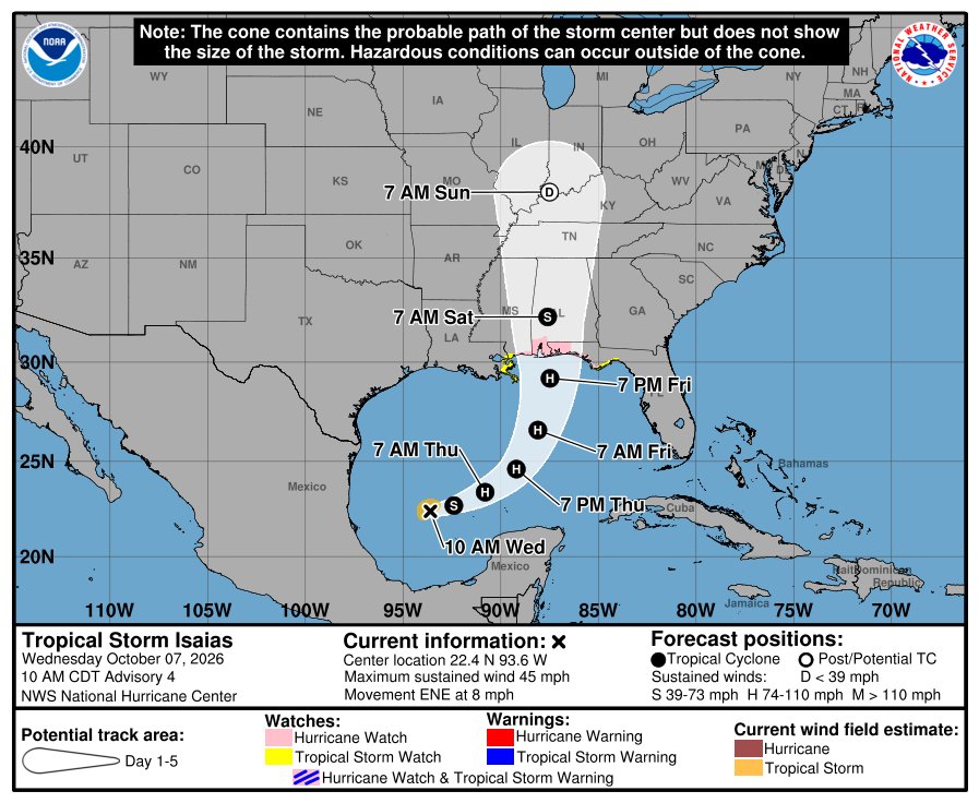
Gov. Ron DeSantis has declared a state of emergency for 25 North Florida and Panhandle counties as Tropical Storm Isaias strengthens in the Gulf. On Wednesday morning, the National Hurricane Center put much of the Panhandle under a Hurricane Watch and forecast Isaias to come ashore Friday evening as a Category 2 hurricane near the Alabama-Florida line.
If you live between Pensacola and the Big Bend, you have about two days to get ready. Here’s what the order does, which counties it covers and what forecasters expect.

Which Florida counties are under the state of emergency?
DeSantis signed Executive Order 26-202 Tuesday night. It covers 25 counties:

Baker, Bay, Calhoun, Columbia, Dixie, Escambia, Franklin, Gadsden, Gilchrist, Gulf, Hamilton, Holmes, Jackson, Jefferson, Lafayette, Leon, Liberty, Madison, Okaloosa, Santa Rosa, Suwannee, Taylor, Wakulla, Walton and Washington.
The order lets the state move money and supplies before the storm hits. Emergency crews are already staging generators, fuel, flood barriers, pallets of bottled water, tarps, sandbags and shelf-stable meals in Leon and Santa Rosa counties so they can be sent out fast. “Floridians should take this time to get disaster plans in place and ensure their hurricane supply kit is stocked,” DeSantis said, pointing residents to FloridaDisaster.org.

Where and when will Hurricane Isaias make landfall?
As of the NHC’s 10 a.m. CDT advisory Wednesday, Isaias had 45 mph winds and was about 540 miles south-southwest of the mouth of the Mississippi River, moving east-northeast. Forecasters expect it to become a hurricane Thursday and peak around 110 mph over the central Gulf.
The forecast track brings the center to the coast near the Alabama-Florida line Friday evening with winds around 105 mph, then inland over Alabama by Saturday morning. The NHC calls it “a strong hurricane” at approach, and warns that residents in the Hurricane Watch area “should prepare for the possibility of long-duration power outages.”
What watches are in effect?
- Hurricane Watch: Bay St. Louis, Mississippi, to Indian Pass, Florida. That includes Pensacola, Destin, Fort Walton Beach and Panama City.
- Storm Surge Watch: the mouth of the Mississippi River to Yankeetown, Florida.
- Tropical Storm Watch: east of Indian Pass to the Aucilla River, and from the Jefferson/Plaquemines Parish line in Louisiana to west of Bay St. Louis.
The NHC says more watches and warnings could be added Wednesday.
How bad could the storm surge be?
If the peak surge comes at high tide, the NHC says water could rise:
- 5 to 7 feet from Ocean Springs, Mississippi, to Indian Pass, Florida, and in Mobile Bay.
- 3 to 5 feet from Indian Pass to the Aucilla River.
- 2 to 4 feet from the Aucilla River to Yankeetown.
The deepest water will be just east of where the center comes ashore. Rainfall of 3 to 6 inches, with up to 10 inches in spots, is forecast from far southeast Louisiana to the Florida Panhandle starting Friday. “Residents in the watch area should follow advice given by local officials and evacuate if told to do so,” the NHC said.
What should Panhandle residents do now?
- Know your evacuation zone and listen to your county emergency management office.
- Fill prescriptions, gas up and get cash before lines form Thursday.
- Stock water, food and batteries for several days without power.
- Bring in or tie down outdoor furniture, and move cars to higher ground if you’re in a surge zone.
The BeezLoop Take
Declaring an emergency three days out was the right move. It costs little and lets the state stage generators and fuel before roads close. Florida’s emergency management system is genuinely one of the best in the country, and this is it working the way it should.
The bigger risk is complacency. This is the first hurricane of a quiet season, it’s October, and a lot of Panhandle residents have mentally closed the book on 2026. A storm that was a disorganized depression on Monday is forecast to be a strong Category 2 by Friday. That’s not much time.
The open question is how far east the storm surge reaches. The forecast keeps nudging the track east. If it shifts again, will Panama City and the Big Bend have enough time to get out?
Also on BeezLoop: Gas is over $4.10, and the price is being set in the Strait of Hormuz, and a September nor’easter flooded the coast from the Outer Banks to Cape Cod.
Sources: National Hurricane Center advisory 4 · NHC forecast discussion 4 · Florida Phoenix · Gov. Ron DeSantis on X · WCJB · CBS Miami